Trail Walking San Cristovo de Cea - Oseira- A Laxe - Photo
© OpenStreetMap contributors
Length
Length
30 km
Max alt
Max alt
818 m
Uphill gradient
Uphill gradient
669 m
Km-Effort
Km-Effort  
39 km
Min alt
Min alt
458 m
Downhill gradient
Downhill gradient
861 m
Boucle
Boucle
No
Creation date :
2023-06-05 04:58:23.514
Updated on :
2023-06-05 14:48:34.836

(0 Reviews)

Walking
Walking
6h51
Difficulty : Difficult

Scan this QR Code to open this trail in the SityTrail application

FREE GPS app for hiking

Logo SityTrail SityTrail

IGN / Geographical institutes

Download SityTrail from the App Store Download SityTrail from Google Play

Logo SityTrail SityTrail World

The world is yours!

Download SityTrail from the App Store Download SityTrail from Google Play Download SityTrail on Huawei AppGallery

About

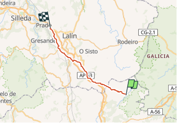
Trail Walking of 30 km to be discovered at Galicia, Ourense, San Cristovo de Cea. This trail is proposed by dagobert5612.

Description

camino de levante

Elevation profile

Positioning

Country:
Spain
Region :
Galicia
Department/Province :
Ourense
Municipality :
San Cristovo de Cea
Location:
Unknown
Start:(UTM)
586031 ; 4710136 (29T) N.

Trails nearby

Trail On foot Rodeiro - PRG-7 Rota do Monte Faro - Photo
On foot
PRO

On foot

Easy
Rodeiro, Galicia, Pontevedra, Spain
5.9 km | 9.9 km-effort
2h 14min
No


Close
My subscriptions